Businesses in Biggs, Rufus, Wasco, Moro and Grass Valley include food services, variety goods, antiques, gifts, rock shops, sporting services, farm implements and supplies, fuel and mechanical repairs.
Volunteers provide many important services including rural and city fire protection, rescue and medical response units, city councils and educational support. Children’s activities include school athletics, Little League, 4-H and FFA projects, church youth groups, summer programs and Scouting. Baptist, Catholic, Church of Christ, Methodist and Presbyterian denominations are represented in the county.
Adults participate in organizations such as Lions Club, Barnstormers [theater group], Sherman County Historical Society/Museum, OSU Extension, Sherman County Cattlemen, Farm Bureau, Oregon Wheat Growers League, Sherman County Athletic Foundation, 4-H leadership, Sherman High School Booster Club and informal group activities.
Sherman County Towns
Rufus
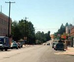
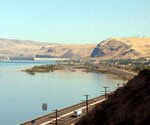 Rufus is located next to Interstate 84, in the beautiful Columbia River Gorge, 100 miles East of Portland and 100 miles West of Pendleton. Primarily a residential community, the population is about 270. Small commercial businesses cater to local residents and interstate highway travelers. The nearby Columbia, John Day and Deschutes Rivers offer recreational opportunities --- camping, fishing, windsurfing, parasailing, rafting and boating. The John Day Dam and Giles French Park are on the Columbia River at Rufus, and LePage Park at the mouth of the John Day River is on I-84 to the east. Rufus is 1 ½ hours from Mt. Hood in Oregon and 1 ½ hours from Mt. Adams in Washington. The town was named for the original white settler there, Rufus C. Wallis.
Biggs
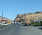 Biggs, on the south bank of the Columbia River, was the junction of the main line of the Union Pacific Railroad and its branch south into Sherman County. Sometimes called Biggs Junction, it was named for W.H. Biggs, pioneer landowner and legislator.
 Biggs is a major crossroads where Highway 97 intersects I-84 and Sam Hill Memorial Bridge crosses the Columbia. The traveling public is served with service stations, truck stops, restaurants, markets, McDonald's and motels. Grain storage elevators and rail and barge shipping facilities serve local grain producers. Its location offers easy access to Maryhill Museum of Art and Maryhill State Park across the Columbia River. A hiking segment on the Oregon Trail and Deschutes State Park are a short distance west. The Journey Through Time Scenic Byway, anchored at Maryhill Museum of Art and Maryhill State Park, runs south to Shaniko and easterly to John Day and Baker City.
Wasco
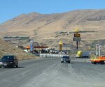
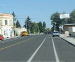
 Wasco, population 380, is located close to the route of the Oregon Trail just north of town, and is named for Sherman County's parent county, Wasco. The first post office in the area was Spanish Hollow, established in 1870 by Jesse Eaton, postmaster. The name was changed to Wasco in 1882, and the town incorporated in 1898.
Industrial and business sites are available in Wasco.
Three exits from Highway 97 direct travelers into Wasco from the Journey Through Time Scenic Byway. Wasco's amenities include the historic Columbia Southern Railway Depot and historic caboose, City Park, Wasco Library, Wasco Church of Christ, Wasco United Methodist Church and St. Mary's Catholic Church. Businesses include Wasco Variety and Video, Wasco Market, Sherman County Insurance, The Gift Horse, Mid-Columbia Producers' Farm Store, a John Deere dealership, Morrow County Grain Growers, Lean To Grill and Goose Pit Saloon. Pre-schools operate in Wasco and Moro, serving three-to-five-year-olds.
Wasco State Airport serves Wasco and Sherman County and is owned by Oregon Aeronautics Division. The paved runway extends for 3,450 feet. The facility is at an elevation of 1,459-1,503 feet at a distance of about one mile from Wasco.
Moro
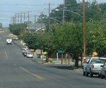
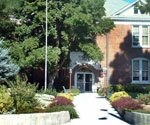
 Moro, population 380, is 18 miles south of Biggs Junction, and the county seat. Sherman County Courthouse overlooks the town (left). The first settler in this location was Henry Barnum about 1868. Apparently the name was selected in a drawing from a hat, Moro being the name proposed by Judge O. M. Scott, who came from Moro, Illinois.
 Amenities include the 1899 Courthouse, a City Park with a Wall of History, Sherman Pre-School and Moro Community Presbyterian Church. Businesses include Bank of Eastern Oregon with ATM, Huskey's 97 Market, Opera House Antiques, Moro Now & Then Antiques, Moro Clinic, Cafe Moro, Sweet Water Bar & Grill, Vista Towing, Mid Columbia Producers and county and federal offices. Sherman Agricultural Research Station overlooks Moro, and the County Fairgrounds and Sherman County RV Park are a half-mile from town. Sherman Health District operates Moro Medical Clinic. Industrial and business sites are available in Moro
The Sherman Agricultural Research Station is located on 234 acres that serve field research needs of scientists from the Oregon State University campus in Corvallis and the Pendleton area Columbia Basin Station. Current research includes that for grain varieties, soil fertility for cereal crops, canola, mustard, other alternative crops, weed management, disease and nematode management, direct seeding practices and the use of soil conservation practices. The Station manager works from an office and operates the weather station and a full complement of farm equipment.
Sherman Junior/Senior High School and the athletic complex, centrally located one mile South on Highway 97, serve the county. Sherman Elementary School is located in Grass Valley. Pre-schools operate in Wasco and Moro, serving three-to-five-year-olds. Sherman County Public/School Library is located at Sherman Jr/Sr High School.
Grass Valley
 Pioneer settlers reported rye grass so tall that it was well over a man's head, even when he was on a horse! Grass Valley was incorporated in 1900, and lies at the head of Grass Valley Canyon that wanders northward through Sherman County.
Grass Valley is a small rural community about 27 miles south of Biggs Junction. Town amenities include Grass Valley Baptist Church, St. John the Baptist Catholic Church, Grass Valley Market, Country Cafe, Road House 97 ( the only gas station between Biggs Junction and Shaniko), small shops and a small outdoor museum called Horses to Horsepower (antique tractors). The town's lovely park offers shade and picnic tables in a beautiful setting with clean public restrooms. It is adjacent to Sherman Elementary School, a small basketball court and baseball diamond.
Kent
Kent is an unincorporated town with a population of 23. Amenities include homes, a Baptist Church and the post office. Mid Columbia Producers operates the grain storage elevator. On Highway 97, Kent is the last outpost southbound, 16 miles to Shaniko. Northbound Kent is 40 miles from Biggs. A handful of families appreciate the wide-open spaces and magnificent view of Mt. Hood. About 1887, the name was selected for the Kent Post Office because it is short.
Hamlets-Long-Gone
 Long-gone, sometimes remembered hamlets, sites of country schools or rail sidings, include Rosebush, Erskine, Bourbon, DeMoss, Rutledge, Wilcox, Gorman, Gordon, Grover, Fargher, Emigrant Springs, Early (for its early spring garden produce on the John Day River), Miller, Monkland, McDonald or McDonald's Ferry (at the John Day River Oregon Trail Crossing), Klondike, Rutledge and Thornberry.